This trip has been cancelled
Bushwalking
Fri 17 - Sun 19 Apr 2026
Posted by Callum L
on Tue, 3 Mar 2026
Leaders:
Callum L
Standard: Intermediate
Meeting: Tue, 14 Apr 2026, 7:00 pm
I’ve done the part of the prom southern circuit before, but haven’t done the southern point and lighthouse segments, so am keen to get down there and see the southernmost point of mainland Australia.
This will be an intermediate trip, all participants must have had previous overnight bushwalking experience to come on this trip.
Swimming is a component of this trip (if participants choose to), therefore anyone wanting to go for a swim must be a competent swimmer who can take care of themselves in the water, as this is a very remote location in the Australian bush, and that comes with its own risks. If you can’t swim or don’t wish to, you are more than welcome on the trip, it’s an additional component at Little Waterloo bay and not an essential part of the trip, but please let me know before the start of the trip.
Last time I was down there and went across to refuge cove there was also a small section of rock scrambling we had to go over, so participants should keep in mind that there is potential for this and should be comfortable with this terrain.
But enough of the serious stuff, for those who don’t know, Wilsons Prom is an incredible and pristine national park on the Southern tip of Victoria just three hours drive from Melbourne. There are hundreds of Kangaroos, wombats and other wildlife that live down here, so while it’ll be a great opportunity to see some Australian wildlife, its important to be respectful of them and the environment and to take all rubbish with you (and if you see any on the trail to pick it up to keep the parks looking great for everyone else too).
The current route I’m considering taking is listed below:
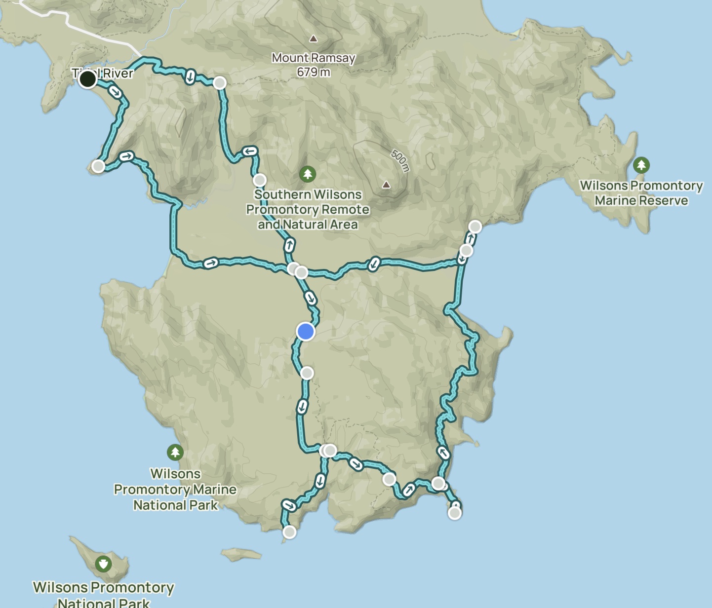
54.2km, 1783 m of elevation
Day one (21.8km, 800m elevation)
- Drive from the clubrooms (around 3 hours) to park at tidal river visitor centre
- Hiking down around Little Oberon via Oberon walking track
- Through Oberon Bay
- Past Oberon Beach Campsite
- Turning south on telegraph saddle track]past halfway hut
- Camping at Roaring Meg
- Dropping packs and heading down to the southern point return (6.2km, 262m elevation)
Day two (15.4km, 627m elevation)
- Leaving Roaring Meg campsite
- Following telegraph walk track east
- Turning down onto the lighthouse track
- Returning up from the lighthouse track and heading north
- Onto the Waterloo bay - south point walking track up to Little Waterloo Bay
- Dropping packs at Little Waterloo campsite
- Going for a swim at little Waterloo bay
Day three (15.5km, 427m elevation)
- From Little Oberon Campsite
- Going south to little Oberon and then West through the Waterloo bay walking track
THEN EITHER
- Joining north onto the telegraph track till Telegraph saddle
- Following the road down to Tidal river
OR
- continue onto the Oberon bay walking track (again) to Oberon bay, and following it to tidal river
(Benefit being that it’s prettier and the telegraph track is low key boring and a steep hill).
A couple more important points
- This trip is expression of interest cause I’ve got a knee injury and will need to see how I’m fairing closer to the time on whether it can go ahead :P
- Ill be prioritising people with cars (until we reach enough spaces - we can have a max of six people on the trip due to campsite restrictions) because I don’t have my own
- I’m also willing to have someone shadow this trip as the first step of bushwalking leader training so if there’s anyone interested in that then lmk.
So yeah get keen!
Back to list of trips